
Location
Total Environment Sarjapur Location
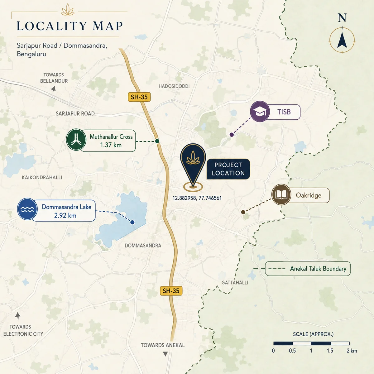
The site fronts the Sarjapura-Ambalipura Main Road (SH-35) at Dommasandra, spanning the Dommasandra and Thigalachowdenahalli villages in Sarjapura Hobli, Anekal Taluk, Bengaluru Urban 562125. The coordinates are 12.882958, 77.746561. Reverse geocoding that pin returns Dommasandra, Anekal, Bengaluru Urban, Karnataka 562125, and the survey numbers in the project's own land schedule fall across the same two villages. Inside the Bengaluru search area, Total Environment Yelahanka helps buyers keep the map conversation grounded in actual routines instead of only distance claims.
SH-35
Road frontage
1.37 km
Muthanallur Cross
562125
PIN, Anekal Taluk
2033
Metro target
Getting Around
Road first, rail later
SH-35 is the spine here, and it does the work in both directions - north towards Ambalipura and the Outer Ring Road tech cluster, south towards Sarjapura town and the Tamil Nadu border road. The nearest usable junction is Muthanallur Cross at about 1.37 km by road. That matters more than it sounds: this is a median-divided highway, so the junction you can actually turn at is not always the one that looks closest on a map, and straight-line distances mislead badly on this stretch.
Drive times on the corridor are honest only at the margins. Free-flow routing figures are close to useless in Bengaluru, and peak-hour reality on the Sarjapur stretch bears little resemblance to them. Buyers should drive the route at 09:00 on a weekday before deciding anything. Some routing engines also return an Electronic City distance of roughly 24.6 km by snapping to the elevated carriageway; that number is an artefact of the routing, not a description of the journey, and is not worth planning around.
Daily Life
What is already around the site
The schools nearest the parcel are the strongest part of the existing catchment. The International School Bangalore and Oakridge International both geocode to Thigalachowdadenahalli - the same village that appears in this project's survey-number schedule - which places them genuinely adjacent rather than merely on the same corridor. That is unusual this far out on Sarjapur Road, where school claims often stretch across ten kilometres of traffic.
Dommasandra Lake sits 2.92 km by road from the site. Retail, healthcare and everyday services concentrate around Dommasandra Junction and Muthanallur Cross rather than at the site itself, which is the normal pattern for a corridor at this stage: employment and housing arrive before the high street does. A buyer moving in at completion should expect to drive for anything beyond daily convenience shopping, and should price that in rather than assume the gap closes on schedule.
What Is Coming
The infrastructure timeline, as it actually stands
The metro line planned for this alignment is now targeted for April 2033, following the DPR revision in mid-2026. That is the single most important number on this page, because it lands roughly three years after the project's filed completion date of February 2030. Anyone buying here on a metro thesis is accepting a three-year gap between moving in and the line opening - and that assumes the revised date holds, which on Bengaluru rail projects is not a safe assumption.
Road-side, the corridor's improvements are the usual mix of junction upgrades and widening proposals at various stages of approval. Where an item is sourced to press coverage rather than a government notification, it should be treated as unconfirmed - a distinction that gets lost quickly in project marketing. The reliable planning position is the one already in force: both parcel villages sit inside the BDA Local Planning Area, and the BDA Revised Master Plan 2031 defines a Dommasandra Special Development Zone across this stretch.
Micro-Market
Reading Dommasandra against the corridor
Dommasandra is where the Sarjapur Road corridor changes character. North of here the addresses carry ORR-adjacency pricing and very little developable land; south and east of here the land is available and the pricing is not yet set. This project sits on the boundary between those two conditions, which is the whole basis of its position: corridor access without corridor land cost, at the price of an infrastructure timeline that runs behind the building programme.
One correction is worth making explicitly, because it is widespread. Several listings for this project carry a Plus Code that decodes to roughly 12.8888, 77.6856 at Choodasandra - about 12.6 km by road west of the real site, in a different taluk and a different PIN (560035). Anything computed from that pin, including school distances, commute times and comparable rates, is measuring the wrong place. Use the coordinates in the table above and discard the Plus Code.
| Reference | Position |
|---|---|
| Coordinates | 12.882958, 77.746561 |
| Villages | Dommasandra and Thigalachowdenahalli |
| Hobli / Taluk | Sarjapura Hobli, Anekal Taluk |
| District / PIN | Bengaluru Urban, 562125 |
| Road frontage | Sarjapura-Ambalipura Main Road (SH-35) |
| Nearest junction | Muthanallur Cross, about 1.37 km by road |
| Dommasandra Lake | 2.92 km by road |
| Planning authority | BDA Local Planning Area, Dommasandra Special Development Zone |
| Metro on this alignment | Targeted April 2033 |
Distances are road distances, not straight-line. On a median-divided highway the two differ enough to change which junction and which station is actually nearest.
Buyer Questions
Total Environment Sarjapur Location - FAQ
Where exactly is Total Environment Sarjapur?
On the Sarjapura-Ambalipura Main Road (SH-35) at Dommasandra, across the Dommasandra and Thigalachowdenahalli villages in Sarjapura Hobli, Anekal Taluk, Bengaluru Urban 562125. The coordinates are 12.882958, 77.746561.
Why do some listings show a Choudasandra address?
A Plus Code circulating with this project decodes to roughly 12.8888, 77.6856 at Choodasandra - about 12.6 km by road west of the real site, in a different taluk with PIN 560035. It is a contaminated field. Any distance or commute time computed from it describes the wrong location.
Which planning authority covers the site?
The Bangalore Development Authority. Both parcel villages appear as full villages in Annexure-1 of the BDA Revised Master Plan 2031, and Volume-4 of the same plan defines the Dommasandra Special Development Zone covering this stretch. Note that naming BDA as the competent authority is not a statement that any plan has been sanctioned.
When will metro reach this part of Sarjapur Road?
The current target is April 2033, following the mid-2026 DPR revision. That is roughly three years after the project's filed completion date of February 2030, so buyers should not assume metro access at possession.
What schools are near the site?
The International School Bangalore and Oakridge International both geocode to Thigalachowdadenahalli, the same village listed in the project's survey-number schedule, which places them genuinely adjacent to the parcel rather than merely on the same corridor.
How far is the nearest junction and lake?
Muthanallur Cross is about 1.37 km by road and is the road-nearest junction - not Dommasandra Junction, which looks closer in a straight line but is not on a median-divided highway. Dommasandra Lake is 2.92 km by road.